
Crookdale Horseshoe - Lake District Walk
Sunday 12th August 2012
After a weekend of birthday celebrations we headed to the Shap Fells for a walk around Crookdale. We appeared to have the fells to ourselves as we didn't meet or even see anyone all day.
Start: Crookdale Bridge (NY 5502 0555)
Route: Crookdale Bridge - High House Bank (352) - Robin Hood (353) - Lord's Seat (354) - Grey Crag (355) - Harrop Pike (356) - Great Yarlside (357) - What Shaw (358) - Crookdale Bridge
Distance: 8.75 miles Ascent: 592 metres Time Taken: 6 hours 15 mins
Terrain: Moorland.
Weather: Generally warm and hazy with a brief light shower.
Pub Visited: Duke of Cumberland, Kendal Ale Drunk: Jennings Cumberland

Looking across Crookdale Beck to Whatshaw Common, which will be the final summit of the day.

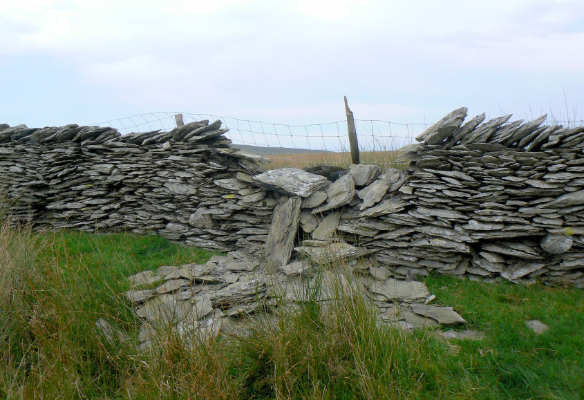
Reaching the top of Hazel Bank our first problem is how to cross the wall to gain access to High House Bank. It really would be much easier if they would just put a stile or gate in.

The first summit of High House Bank, like several of today's summits has nothing to mark it.

Looking along High House Bank's ridge, with Borrowdale to the left and Crookdale to the right.

Looking back at the descent from the col.

We will soon be climbing again as ahead lies Robin Hood, the next summit of the day.

I went in search of the cairn which lies just below the summit. John is standing on the actual summit.

The view down Borrowdale made the small diversion worthwhile.

The actual summit of Robin Hood with Great Yarlside in view across the valley.

From Robin Hood we headed towards Lord's Seat. On route we debated the merits of descending into the valley to climb back up to Great Yarlside against continuing upwards to the ridge on the horizon and following the ridge to Great Yarlside.

By the time we had reached Lord's Seats summit we had opted for the climb to the ridge.

We had intended to aim for Harrop Pike but headed too far to the left and instead ended up at the summit of Grey Crag.

Our reward was the view down into Longsleddale. It doesn't seem that long since we were looking into the valley from the other side.

An easy walk across some boggy ground would take us to Harrop Pike.

We had to cross the fence to access Harrop Pike's summit cairn.

From Harrop Pike another easy walk across moorland took us to Great Yarlside.

Despite looking for the sunken trig point I we couldn't find it. It turned out we were looking too far way from the wall. The actual summit was hard to identify but these stones seemed close to it according to the GPS.

The rest of the route is easy to identify, just follow the wall down to Little Yarlside.
The summit of Little Yarlside was across this wall. As there was no easy crossing point for someone with legs as short as mine it will have to be visited on another day, I'm not prepared to damage walls just to gain access to a summit. In actual fact if we had crossed to the other side of the wall just before we reached Great Yarlside we could have got there easily as there is also a place to cross the wall on route to What Shaw.

We carry on following the wall to What Shaw Common.

This impressive cairn on What Shaw lies below the actual summit.

Looking back to Great and Little Yarlside, where a clear path can be picked out to the right of the wall.

Like the first summit of the day the final summit has nothing to mark it.

Back to the car which is parked next to Crookdale Bridge. The only challenge now is to get back home in time for the Closing Ceremony of the Olympic Games.
All pictures copyright © Peak Walker 2006-2023